Google Immersive Geospatial Challenge Winner Becomes Cesium Certified Developer
One of our newest Cesium Certified Developers is Moritz Cermann, a student at the Technical University of Applied Sciences Würzburg-Schweinfurt, whose Cesium-based application won the Best of Entertainment and Events category in the Google Immersive Geospatial Challenge.

Moritz Cermann, Cesium Certified Developer
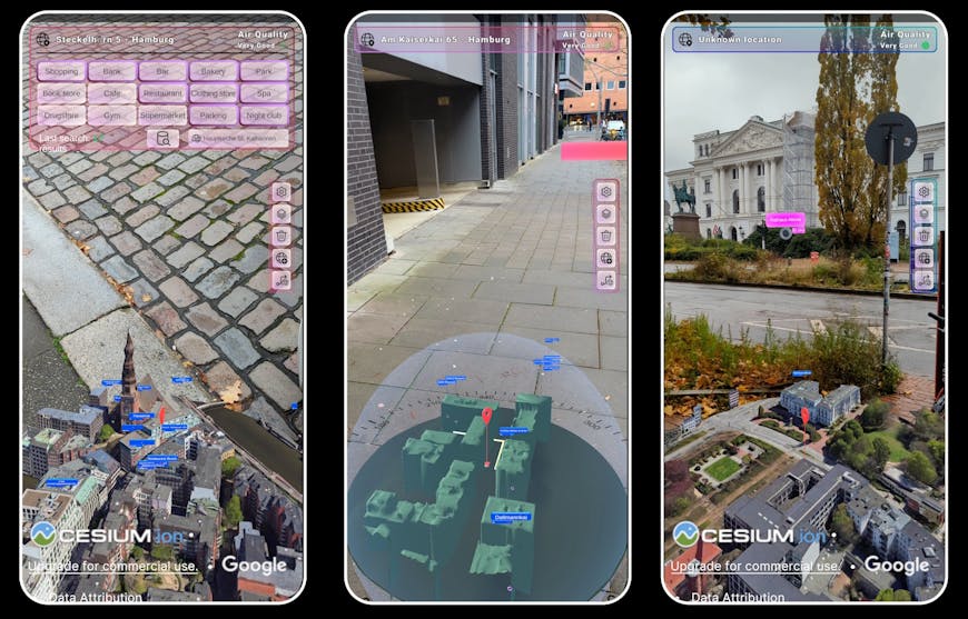
The challenge invited participants to create location-based virtual or augmented reality (AR) applications. Using Google Photorealistic 3D Tiles and Cesium for Unity, Moritz created navigAtoR, a demo app intended to inspire a vision of more immersive navigation experiences.
It certainly inspired us! navigAtoR is an AR phone app that makes navigation more intuitive with a 3D model of the user’s location. navigAtoR enables highly accurate direction and position accuracy, which is essential to displaying location-based content and critical to lining up Google Photorealistic 3D Tiles perfectly with the real world. With 3D Tiles, Moritz was able to stream these highly detailed photorealistic 3D Tiles datasets to edge devices, creating a world-scale app.
“Typically, maps for navigation are only displayed in 2D, which often lead to confusion. But with recent advances in hardware, efficient 3D geospatial platforms like Cesium, and 3D Tiles for streaming massive datasets, we've reached a point where 3D navigation can be implemented and used in our daily life.”
- Moritz Cermann

In navigAtoR, Google Photorealistic 3D Tiles streaming in Cesium with an AR navigation app allows users to find points of interest and directions, all in a context that matches where they are standing.
Moritz included his app as part of his application to become a Cesium Certified Developer. This program recognizes the technical expertise of developers who build on the Cesium platform. Moritz applied to be a Cesium Certified Developer so he could connect with like-minded individuals also engaged in developing innovative 3D spatial solutions.
Moritz sees many use cases for geospatial AR beyond navigation. Not only would displaying a 3D map of a user’s surroundings make navigation more intuitive, but the ability to overlay virtual elements onto reality opens numerous possibilities: placing the model for a planned building precisely where it is meant to be constructed, adding vegetation to barren areas, bringing robots to life–all visualized in their exact corresponding location in the real world. Moritz has explored other future possibilities in travel-compAnIon, a demo app created for the GoogleAI Hackathon using Cesium with Gemini, Google’s LLM, as a tourist guide.
If you’re also working with Cesium, consider applying to become a Cesium Certified Developer.