Preserving More Metadata for Point Clouds Using 3D Tiles
Cesium ion’s 3D Tiling Pipeline now preserves all LAS Point Data Record Formats (PDRFs) in 3D Tiles, advancing runtime analytics using per-point metadata.
Aerometrex point cloud data of Sydney Harbour Bridge, Sydney, Australia.
LAS is an industry standard for LiDAR point cloud data and widely used across industries including mission planning and defense, transportation, energy, telecom, AEC, Earth and environmental science, and more.
Per-point metadata enriches individual data points with additional information beyond their spatial coordinates, improving analysis, decision-making, and the capability to accelerate use cases through AI algorithms in real time.
In 3D Tiles, we place a large emphasis on metadata because of its increasing availability and users’ needs. Just as sensor, vehicle, compute, and data capture trends have enabled us to capture the real world with ever-increasing resolution, modern AI algorithms are increasingly adding even more semantically rich metadata to augment 3D models and point clouds. This update adds to the previously preserved metadata fields including position, color, classification, and intensity, enabling users to understand and identify characteristics like the materials that make up a building, the density of soil, and other details that accelerate analysis and operations.
The LAS 1.4 specification defines 10 PDRFs which contain per-point properties like GPS time, near-infrared channel, scan angle, scanner channel, and edge of flight line. These properties are generated by scanning hardware and processing software into the point clouds. Cesium’s 3D Tiling Pipeline reads and transcodes these properties into 3D Tiles metadata, which can then be used for visualization, styling, or analytics using CesiumJS, Cesium for Unreal, Cesium for Unity, or Cesium for Omniverse.
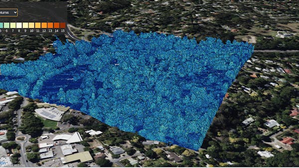
Aerometrex data of Stirling, South Australia, showing the “number of returns” property. Each LiDAR pulse can have multiple return reflections, showing different levels of vegetation. The lighter color shows higher return values for trees.
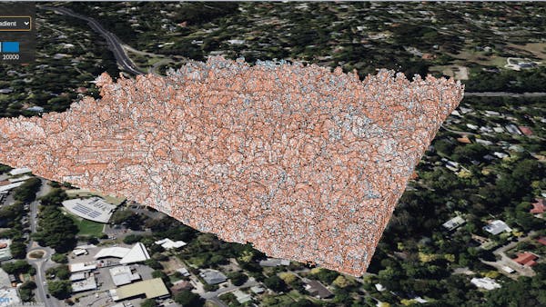
Aerometrex data of Stirling, South Australia, showing the “scan angle” property. The LiDAR scanner sweeps left to right (and vice versa). This shows a simple representation of if the angle was positive or negative.
PDRF support is an important incremental step toward supporting AI-generated semantic metadata, commonly made available via LAS’s Extended Variable Length Records (EVLRs), which help define custom fields per-point. If you use EVLRs and are interested in 3D Tiles preserving EVLRs, contact Cesium.
Sign up for Cesium ion and upload your point clouds today.