Deutsche Bahn Prepares for Fully Automated Trains with CesiumJS within Sector Initiative Digitale Schiene Deutschland
Quality and efficiency are paramount for public transportation, especially as scheduling and driving are increasingly automated. Digitale Schiene Deutschland (DB InfraGO) is preparing for automated trains by mapping German rail lines and surrounding areas in 3D with CesiumJS-based tools.

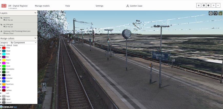
Objects within point clouds are identified, labeled, and displayed as GeoJson with CesiumJS. Courtesy DB InfraGO AG.
“Less traffic, less congestion, less particulate matter—and more people and more goods on the rails: the rail sector in Europe is on the verge of a technological leap into the digital future. Within the sector initiative ‘Digitale Schiene Deutschland,’ DB InfraGO, a subsidiary of Deutsche Bahn, is taking advantage of this opportunity and bringing future technologies into the rail system,” Deutsche Bahn explained.
Although 2D maps of the Deutsche Bahn railway system have existed for decades, Digitale Schiene Deutschland is working to combine assets, such as rails, platforms, signals, and landmarks, into one system, against which train sensors can reconcile what is around them for appropriate decisions. This is best done in 3D to ensure accurate shapes and locations through object detection and environmental awareness, and the data is visualized in CesiumJS as a key part of Digitale Schiene Deutschland's Digital Register.
Rail-specific information and geospatial context from the Digital Register inform perception and localization systems. Digitale Schiene Deutschland has added this data for Hamburg in the research project “Sensors4Rail” and will continue the work in the project “Automated Train” with the S-Bahn in Stuttgart. With mere centimeters of wiggle room to ensure a train does not hit a platform or the “understanding” that an object on the rails should not be there and thus requires a stop for safety, real-world data results in realistic virtual environments for training the trains, so to speak—one day allowing fully automated journeys.
Raw point clouds of the rails and immediate surroundings are paired with Cesium’s datasets. Courtesy DB InfraGO AG.
Using both terrestrial lidar and photos from devices mounted on slowly moving measurement trains, Digitale Schiene Deutschland collects dense point clouds: billions of points, terabytes of data. The organization leverages Cesium ion to host these massive point clouds in their own environment, tile into 3D Tiles for efficiency, and stream them along with Cesium World Terrain and Sentinel-2 imagery to CesiumJS. Objects within the point clouds are identified and labeled, to reduce data size when the map data is transferred to perception and localization systems. Within the Digital Register, all Cesium datasets can be easily visualized, ensuring accurate mapping of assets and realistic surroundings.
Prior to Cesium, the railways’ developers were using a solution that allowed their team to visualize only a few meters of the tracks and only on specific computers. With CesiumJS, anyone on staff can interact with the 3D data in a web browser, rather than needing specialized software or high-performance computers.
“Cesium products make it easy to collaborate with 20-30 coworkers with performant visualizations,” said Gordon Isaac, product owner for 3D maps at Digitale Schiene Deutschland/DB InfraGO AG.
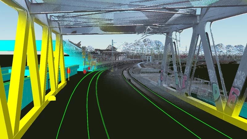
Using both terrestrial lidar and devices mounted on slowly moving trains, Digitale Schiene Deutschland collects dense point clouds. Courtesy DB InfraGO AG.
To enhance quality for passengers and usher in the next era of travel, Digitale Schiene Deutschland is bringing maps of Germany’s rail lines into accurate, interactive 3D.
Request a Cesium ion Self-Hosted evaluation to begin creating and hosting 3D content in your own environment.