COMSPOC Delivers Space Situational Awareness with CesiumJS
To warn of on-orbit threats and natural hazards, COMSPOC Corporation uses CesiumJS to deliver space domain awareness and space situational awareness for civil and defense applications in near real time.
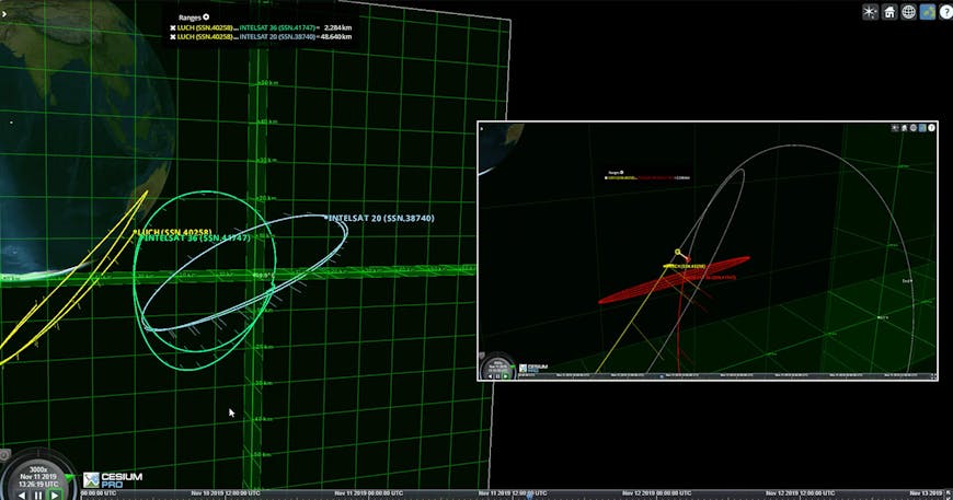
COMSPOC Corporation uses CesiumJS to deliver space domain awareness and space situational awareness. Courtesy COMSPOC.
COMSPOC, operating 24/7/365 since 2014, began at Analytical Graphics, Inc. along with Cesium and spun out as a separate company years later. It is the original marquee use case for Cesium.
Space is a busy place: according to celestrak.org, there are more than 28,000 cataloged human-made objects larger than 10 cm orbiting Earth, with over 9,000 of them active satellites, and in 2022 alone the world sent nearly 2,500 objects to space. Sure, space is vast, but Low Earth Orbit (LEO)—with the International Space Station, USGS Landsat satellites, and thousands of telecommunications satellites—is becoming increasingly crowded. Medium Earth Orbit (MEO) is home to GPS satellites, and Geosynchronous Earth Orbit (GEO) is where you’ll find satellites for communications and weather.
Although MEO and GEO are enormous, spacecraft must get through LEO on their way to their final orbits and must be physically larger; it’s vital to determine safe launch windows and collision probabilities. Space exploration has included unintentional collision events between satellites on orbit, such as Iridium/Cosmos in 2009, and intentional destruction, such as anti-satellite (ASAT) testing, which the United Nations resolved to halt at the end of 2022. To alert space organizations to these collision possibilities, calculate miss probabilities, and characterize maneuvers and events, COMSPOC relies on CesiumJS for time-dynamic visualizations.
This video illustrates that intentionally, or unintentionally, satellites of different nations or companies more and more often get “close” enough to generate possible collision alerts. Courtesy COMSPOC.
COMSPOC processes sensor observation formats, such as right ascension and declination angles or range, and produces orbit solutions in two-line element (TLE) sets or its own high-definition ephemeris format, which provides calculated positions of space objects at regular intervals. This information comes from sensors owned by COMSPOC and those of its data provider partners.
The COMSPOC catalog is scalable to over 100,000 objects. Users don’t need to view the entire catalog COMSPOC is capable of producing; they can filter by orbit regime, country, or mission, for example. Because COMSPOC is built on CesiumJS, it is open, interoperable, and scalable, enabling collaboration and customization—and providing actionable insights to users in near real time, protecting critical assets on orbit and connectivity on Earth.
This video illustrates an attempt to “confuse” custody and attribution of on-orbit satellite operations by showing a satellite “occupy” the space of another satellite, creating uncertainty of object identification. Courtesy COMSPOC.
In addition to its data services and products, the COMSPOC team researches space sustainability and orbital debris mitigation, along with a multitude of other topics, and advocates for responsible operations across international security, academia, and civil and commercial space organizations.
Visit COMSPOC in Cesium’s booth #559 at I/ITSEC in Orlando on November 27, 2-6 p.m. ET, and at the Space Sustainability Workshop in Tokyo on November 28.
Explore how other aerospace companies are using Cesium.