Gilytics Plans Energy Systems with CesiumJS
With a need to change, update, and protect energy infrastructure come the physical implementation of a build and the sometimes-serpentine planning and approvals processes, including public buy-in. Built on CesiumJS and other software components, Gilytics’ Pathfinder is a cloud-based platform for designing and planning energy infrastructure, enabling automation and collaboration for utilities, planners, engineers, and residents.
Tutorial showing Cesium-powered 3D features in Pathfinder. Courtesy Gilytics.
Pathfinder began as founder Stefano Grassi’s research project in 2011, supported by Swiss federal grants. Grassi’s team replaced the project’s previous mapping application with CesiumJS in 2014, just two years after it was released as open source, and in 2017 Grassi founded Gilytics and formally released Pathfinder as a comprehensive infrastructure siting, routing, visualization, analysis, and presentation solution for the energy industry. Based on the spatial constraints defined in a friendly UI, Pathfinder calculates the optimal locations and routes for pipelines, overhead and underground power lines, and wind and solar plants using its proprietary optimization engine based on advanced graph algorithms.
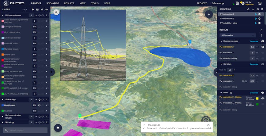
Visualization of automated optimal solar plant siting and line connection results in Pathfinder on top of calculated resistance map and Cesium ion assets. Courtesy Gilytics.
Pathfinder lets users manage data imported from a variety of formats: point clouds, OBJ, KML, GeoTIFFs, and GeoJSON, among others, collected from federal agencies and utilities. The CesiumJS-based 3D viewer seamlessly integrates these input datasets with Pathfinder’s results: resistance maps, corridors, optimal sites and routes, and impact and visibility analysis, including interactive editing. Pathfinder uses Cesium ion assets to provide accurate 3D maps and display large reference datasets, tiled into 3D Tiles and streamed to CesiumJS in the Pathfinder web app.
Pathfinder’s users—the public in particular—can interact with the 3D visualizations to fly through proposed energy projects, observing the location of corridors, pylons, and cables, for example, and identifying impacts to locations they care about. Because the visualizations use Bing Maps Aerial imagery and Cesium World Terrain in addition to images from Google, OpenStreetMap, and national providers like Swisstopo, planners and citizens are seeing projects with an accurate geospatial context, increasing transparency and trust.
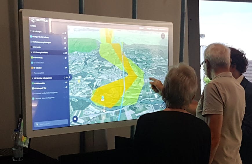
Pathfinder used in an interactive public engagement activity. Courtesy Gilytics and Swissgrid.
How can real-world data in your web app improve energy project design and communication? Get started with our CesiumJS tutorials.