Cesium Release Roundup August 2020
This month we made a lot of improvements to Cesium OSM Buildings. We’ve also increased the cadence at which we update our dataset from the OpenStreetMap data, so you can expect your apps streaming Cesium OSM Buildings to always reflect the latest data available.
Analytical Graphics, Inc., has also added support for Cesium OSM Buildings to their Systems Tool Kit. This means users of STK 12.0.1 and later can stream global buildings with 3D Tiles to perform high fidelity analysis even in urban environments, such as when objects have line of sight.
Cesium ion updates
In your Cesium ion account you’ll find numerous improvements to Cesium OSM Buildings, including:
- Cesium OSM Buildings now uses the latest OSM data as of July 29, 2020.
- Fixed buildings with an incorrect height or missing parts by improving compatibility with non-standard or partially incorrect OSM building tags.
- Fixed many buildings which were not correctly clamped to Cesium World Terrain.
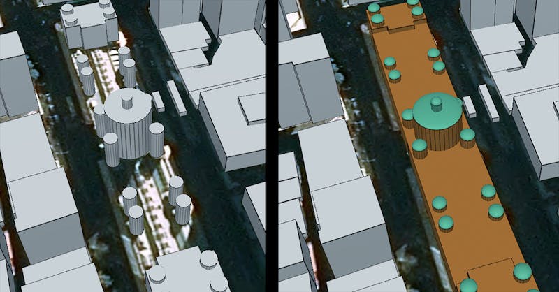
The Queen Victoria Building in Sydney, Australia. Left: Because of incorrect building tags, the main part of this building was missing. Right: The entire building now rendering correctly after our latest fixes to how Cesium ion reads the OSM data. Thank you Russell Grew for bringing this issue to our attention.
Your applications using Cesium OSM Buildings will automatically reflect these changes. We’d love to see what you’re doing with this global building layer! Let us know on the forum.
CesiumJS 1.72 release
CesiumJS 1.72 is now available. Highlights of this release include:
- Added support for glTF multi-texturing.
- Fixed 3D Tileset replacement refinement when leaf is empty.
- Fixed an issue where wall geometry is not rendered in the underground.
- Fixed an issue where clipping planes would not clip at the correct distance on some Android devices.
See the changelog for a full list of updates and links to the discussion & code on each one.
swissgeol visualizes Switzerland’s geological resources
Camptocamp has done some amazing work for swissgeol with the new subsurface rendering added in CesiumJS 1.70. The app brings together numerous underground datasets from Switzerland’s Federal Office of Topography, including boreholes, seismic data, and bedrock maps. While this data was previously available separately and in 2D, swissgeol brings them together in a CesiumJS viewer and streams with 3D Tiles, giving geological engineers and decision makers better tools to analyze potential projects.